| |
The
Project
Both the long history of nautical activity and the presence of
so many different maritime cultures make the Black Sea an ideal
location for underwater archaeological research. A considerable
amount of archaeological investigation has been conducted along
the southern coast of Ukraine, revealing intensive settlement dating
back more than three millennia. Reliance on the sea, both for communication
and trade, is an element common to all periods of this region's
history. The historical importance of the extensive river systems
of central and eastern Europe is well established. The Black Sea,
into which many of these rivers flow, has served as a conduit for
trade and communication between Europe, Central Asia and the Mediterranean.
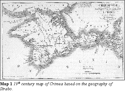
With its central location in the Black Sea, Crimea has frequently
been the focus of maritime activity in this region (Map
1).
 The cultural development of this region is inextricably linked
to maritime activity. The information recovered from shipwrecks
and harbors is critical to the study of the history of the Black
Sea region. The recovery and interpretation of this information
is the focus of nautical archaeology. Ukrainian and Russian researchers
have only just begun to take advantage of the potential for nautical
archaeology of the Black Sea in recent decades. Given the vast amount
of work to be done and limited resources, however, they have barely
scratched the surface of what should be a highly promising region.
Recent developments in the political arena have opened up this area
to Western scholars in a way never before possible. The opportunity
for collaborative work between Ukrainian and American nautical archaeologists
has never been better. The cultural development of this region is inextricably linked
to maritime activity. The information recovered from shipwrecks
and harbors is critical to the study of the history of the Black
Sea region. The recovery and interpretation of this information
is the focus of nautical archaeology. Ukrainian and Russian researchers
have only just begun to take advantage of the potential for nautical
archaeology of the Black Sea in recent decades. Given the vast amount
of work to be done and limited resources, however, they have barely
scratched the surface of what should be a highly promising region.
Recent developments in the political arena have opened up this area
to Western scholars in a way never before possible. The opportunity
for collaborative work between Ukrainian and American nautical archaeologists
has never been better.
Nautical archaeology is a new discipline, but it has already made
an enormous impact. Through the work of Dr. George Bass, founder
of the Institute of Nautical Archaeology (INA), and other pioneers,
this field has demonstrated its importance to the larger archaeological
community and has consequently enjoyed rapid growth in recent years.
INA has encouraged the growth of nautical archaeology, conducting
and supporting projects around the world. For example, INA has developed
a close, working relationship with the Turkish Ministry of Culture.
This relationship has led to several underwater excavations and
surveys as well as the construction of permanent exhibits in the
Bodrum Museum of Underwater Archaeology in Bodrum, Turkey. Through
the cooperative efforts of Turkish archaeologists and INA, the maritime
history of Turkey is being recorded and presented both to the academic
community and the general public.
On a recent trip to Ukraine, Mr. Gidden made contact with Sergei
Zelenko, director of the Underwater Archaeology Research and Training
Center of Kiev University (UARTC). Mr. Zelenko and his colleagues
have been carrying out preliminary coastal surveys in Crimea since
1991. The initial results of these surveys, including the preliminary
identification of the ancient port of Lampas, mentioned in "Periplus
Ponti Euxini" by Ps.-Arrian (2nd century AD), well illustrate the
enormous potential of this region. At the invitation of Zelenko
and his colleagues, we are preparing for a joint project with the
UARTC commencing the summer of 1997. This project could form the
basis for long-term cooperation in nautical archaeology between
INA and UARTC throughout the greater Black Sea region. We believe
this will eventually facilitate a relationship between INA and Ukraine
analogous to the institute's role in Turkey.
Seafaring in the Northern Black Sea:
A Historical Overview
The southern coast of the Crimean peninsula has been the focus
of intense maritime activity for nearly three millennia. From the
earliest historical references to Greek colonization of the Crimean
coast in the 8th century BC, Crimea has been home to numerous cultures:
ancient Greeks, Scythians, Byzantines, Goths, Genoese, Turks, Russians,
and Ukrainians, among others. The location of Crimea provided its
masters with an excellent base from which to exploit the resources
of the Black Sea and its hinterland as well as defend access to
these resources from outsiders. Due to the mountainous nature of
the peninsula's interior, most of the occupation of Crimea was focused
on the coast until recent times. This history provides an excellent
potential for dramatic discoveries along the Crimean coast.
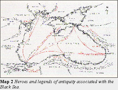 The Black Sea features prominently in the earliest histories and legends
of the Mediterranean world. Ancient authors and storytellers set
their tales of gods and heroes in the Black Sea - a region on the
fringe of their known world (Map 2). The perils
and riches which these early stories attribute to the region reflect
the mystique which surrounded the Black Sea in ancient times. The
Greeks originally referred to the Black Sea as Pontos Axeinos
- the Inhospitable Sea - for good reason. Large sections of
the southern and Crimean coasts are mountainous and offer few protected
anchorages. Violent storms and dangerous winds from both north and
south made navigation treacherous for ancient mariners. Despite
these hazards, however, the Mediterranean cultures were drawn to
the Black Sea by its enormous economic potential. The story of Jason
and the Golden Fleece, while fictional, illustrates the great value
placed on the resources of the Black Sea by the ancient Greeks.
The lure of mineral and agricultural wealth offset the dangers of
sailing into these unchartered waters. The Black Sea features prominently in the earliest histories and legends
of the Mediterranean world. Ancient authors and storytellers set
their tales of gods and heroes in the Black Sea - a region on the
fringe of their known world (Map 2). The perils
and riches which these early stories attribute to the region reflect
the mystique which surrounded the Black Sea in ancient times. The
Greeks originally referred to the Black Sea as Pontos Axeinos
- the Inhospitable Sea - for good reason. Large sections of
the southern and Crimean coasts are mountainous and offer few protected
anchorages. Violent storms and dangerous winds from both north and
south made navigation treacherous for ancient mariners. Despite
these hazards, however, the Mediterranean cultures were drawn to
the Black Sea by its enormous economic potential. The story of Jason
and the Golden Fleece, while fictional, illustrates the great value
placed on the resources of the Black Sea by the ancient Greeks.
The lure of mineral and agricultural wealth offset the dangers of
sailing into these unchartered waters.
The evidence for Bronze Age Mediterranean seafarers in the Black
Sea is not limited to mythology. Mycenaean anchors and oxhide-shaped
copper ingots have been found off the western coast of the Black
Sea. This aspect of Bronze Age seafaring, however, remains largely
unexplored. The discovery and excavation of a Bronze Age shipwreck
in these waters would revolutionize our knowledge of Bronze Age
trade and shipbuilding. INA has considerable experience in Bronze
Age nautical archaeology, having excavated two of the most important
shipwrecks from this period at Cape Gelidonya and Ulu Burun, Turkey.
While the possibility of finding a coherent Bronze Age wreck in
Crimea is somewhat remote, the potential for shipwrecks from the
beginnings of Greek colonization (7th - 5th c. BC) onwards is much
greater. In order to better exploit the resources of the region,
trade centers were established by several Greek cities along the
Black Sea littoral. Colonization generated a dramatic increase in
maritime activity, both for trade and communication. Despite major
disruptions in the interior, Crimea persisted as a center for trade
between the Mediterranean and Eurasian steppe for more than 2000
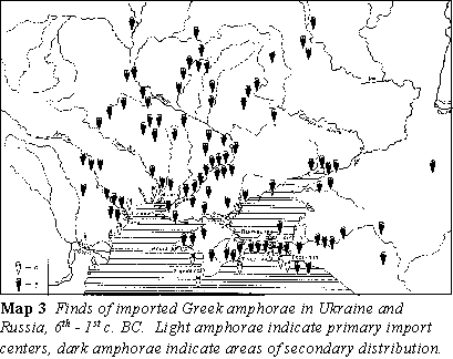
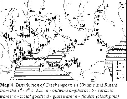
years due to its favorable geographical location. The best evidence
for the extent of maritime activity on the northern Black Sea coast
comes from terrestrial archaeology. The distribution of imported
goods from the Mediterranean (Maps 3, 4)
clearly illustrates the volume of Mediterranean trade in the Black
Sea from the 6th century BC through the 4th
century AD.
Both the ancient Greeks and Romans relied heavily on grain, fish,
salt, and other resources from the Black Sea hinterland to satisfy
the needs of their large urban populations. In exchange, oil, wine,
and finished products were imported for consumption by the colonists
and native population. These bulk food products were carried in
amphorae, two-handled transport jars. Amphorae are important to
archaeologists for several reasons. The shape and size of amphorae
are highly distinctive, often indicating the place and date of their
manufacture. Stamps on handles and etched graffiti provide data
on merchants and manufacturers. This information can be used to
reconstruct economic history. Texas A&M Professor Fred van Doorninck's
studies of amphora capacities revealed a previously unknown standardization
of measurement in the Byzantine period. Amphorae of both local and
foreign manufacture have been found in the Crimea, reflecting the
volume and breadth of trade on the peninsula over more than 1500
years. Figures 1 and 2 are examples
of amphorae from land sites on the section of the Crimean coast
along which the team will be surveying.
  Complete amphorae are infrequently found in land archaeology, and often
only in small numbers. Hundreds of intact amphorae are found on
individual shipwrecks, thus providing a unique resource for the
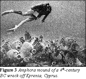
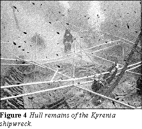
study of economic history. Amphora mounds on the sea floor frequently
mark the location of shipwrecks. Along with the accumulation of
sediment, the amphorae help protect the wooden hull and fragile
artifacts which would otherwise be lost. The 4th-century
BC wreck excavated off Kyrenia, Cyprus well illustrates the potential
of underwater archaeology. Marked by its large amphora mound (Figure
3), the Kyrenia shipwreck was well protected by a layer
of sediment which quickly covered the wreck following its sinking.
Beneath the amphorae and sediment, nearly 60 per cent of the wooden
hull was preserved (Figure 4). This degree of preservation
is rare in the eastern Mediterranean. Slow sedimentation rates and
a rocky bottom prevent preservation of wooden material on the sea
floor. Complete amphorae are infrequently found in land archaeology, and often
only in small numbers. Hundreds of intact amphorae are found on
individual shipwrecks, thus providing a unique resource for the
study of economic history. Amphora mounds on the sea floor frequently
mark the location of shipwrecks. Along with the accumulation of
sediment, the amphorae help protect the wooden hull and fragile
artifacts which would otherwise be lost. The 4th-century
BC wreck excavated off Kyrenia, Cyprus well illustrates the potential
of underwater archaeology. Marked by its large amphora mound (Figure
3), the Kyrenia shipwreck was well protected by a layer
of sediment which quickly covered the wreck following its sinking.
Beneath the amphorae and sediment, nearly 60 per cent of the wooden
hull was preserved (Figure 4). This degree of preservation
is rare in the eastern Mediterranean. Slow sedimentation rates and
a rocky bottom prevent preservation of wooden material on the sea
floor.
Conditions in the Black Sea, however, offer the potential for excellent
preservation. The sea bottom along the Crimean shore is primarily
composed of silty clay deposits. Organic preservation in this matrix
is known to be exceptionally high. The navigational and geographic
hazards mentioned above undoubtedly contributed to numerous shipwrecks
along the Black Sea coast; records from the historic period document
hundreds of shipwrecks. Combined with the crucial role of the Black
Sea in maritime history, these factors offer a high potential for
significant discoveries.
 The commerce and
colonization of Crimea would have been impossible without ships.
Today, as in antiquity, ships are the most economical and safest
form of transportation for large cargoes. Despite the importance
of seafaring to the history of the Black Sea, however, our knowledge
of the types of vessels which sailed the Black Sea is very limited.
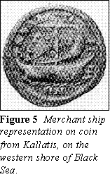
The seafarers who traded in and colonized the Black Sea sailed ships
of Mediterranean design. A limited number of representations depicting
galleys and sailed vessels have been found in Ukraine. Although
not from the northern Black Sea, an ancient coin found in Kallatis
(Figure 5) illustrates a ship type which must have
played an important role in the commercial life of the colony. Most
of these representations are very crude and provide little specific
information other than the general ship types which sailed in the
region. The commerce and
colonization of Crimea would have been impossible without ships.
Today, as in antiquity, ships are the most economical and safest
form of transportation for large cargoes. Despite the importance
of seafaring to the history of the Black Sea, however, our knowledge
of the types of vessels which sailed the Black Sea is very limited.
The seafarers who traded in and colonized the Black Sea sailed ships
of Mediterranean design. A limited number of representations depicting
galleys and sailed vessels have been found in Ukraine. Although
not from the northern Black Sea, an ancient coin found in Kallatis
(Figure 5) illustrates a ship type which must have
played an important role in the commercial life of the colony. Most
of these representations are very crude and provide little specific
information other than the general ship types which sailed in the
region.
The ancient pattern of colonization and trade in the Black Sea continued
through the Byzantine period and into the Middle Ages. Many scholars
have relegated the Black Sea to the periphery of the Byzantine world,
but historical sources contradict this view. The economic importance
of the Black Sea grew dramatically during the early medieval period
as a result of the Arab invasions of the eastern Mediterranean in
the seventh century. To avoid the hazards of piracy and war in the
Mediterranean, the lucrative trade between Europe and the Near East
was redirected through the Black Sea and the land and riverine trade
routes of eastern Europe. The enormous wealth generated by this
commerce attracted the attention of newcomers to the Black Sea region
- Scandinavian merchant-mercenaries.
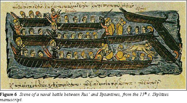
The commercial interests of these merchant-mercenaries were integral
in the early development of the Rus state. Byzantine, Rus and Arabic
sources document the extensive commercial and military activity
of the Rus throughout the northern Black Sea region. Competition
for access to the commercial wealth of the Black Sea quickly brought
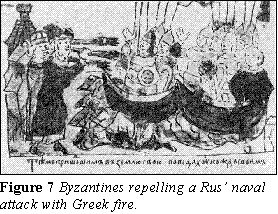
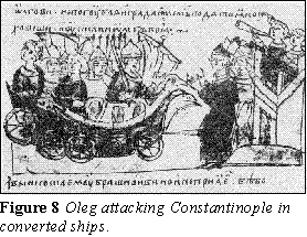
the Rus and Byzantines into conflict. Several seaborne attacks were
launched by the Rus across the Black Sea against Constantinople
(Figures 6, 7 and 8). The essentially
commercial nature of this rivalry is demonstrated by the trade treaties
which concluded these conflicts regardless of the success or failure
of the Rus attacks.
Rus leaders were well aware of the importance of the Black Sea to
the economic welfare of their state. While quite remote from the
Black Sea, Kiev rose to preeminence among the Rus principalities
through its strong links with Black Sea trade. Prince Svyatoslav
even attempted to relocate his capital to the Black Sea, at the
mouth of the Danube, to improve the commercial position of his state.
While early Rus-Byzantine relations were essentially military and
commercial in nature, they eventually expanded into the cultural
sphere as well, as reflected in the Byzantine influence on Rus architecture
as well as the Rus conversion to Christianity in AD 988. These ties
secured continuous trade relations between the two states until
the fall of Kiev in the mid-13th century.
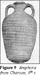 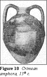 As in
antiquity, a lively trade between the Mediterranean and Black Sea
continued through the Middle Ages, as demonstrated by finds of cargo
amphorae in Crimea (Figures 9 and 10).
In addition, locally manufactured amphorae and trade goods were
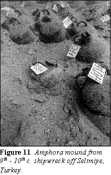
being shipped abroad from Crimea. INA's excavation of a 9th-century
Byzantine merchant ship (Figure 11) off the southwestern
coast of Turkey, under the direction of Texas A&M University
Professor Frederick Hocker, has revealed a cargo of more than 1000
wine amphorae whose closest parallels were manufactured in Crimea
(Figure 9). As in
antiquity, a lively trade between the Mediterranean and Black Sea
continued through the Middle Ages, as demonstrated by finds of cargo
amphorae in Crimea (Figures 9 and 10).
In addition, locally manufactured amphorae and trade goods were
being shipped abroad from Crimea. INA's excavation of a 9th-century
Byzantine merchant ship (Figure 11) off the southwestern
coast of Turkey, under the direction of Texas A&M University
Professor Frederick Hocker, has revealed a cargo of more than 1000
wine amphorae whose closest parallels were manufactured in Crimea
(Figure 9).
Despite the collapse of the Rus state and the waning of Byzantium's
influence in the Black Sea in the 13th century, the Black
Sea remained a center of maritime trade. Italian merchants, primarily
Genoese and Venetian traders, continued a lucrative trade in luxury
goods from the Near East, as well as agricultural goods and slaves
from the Eurasian steppe. The Italian trading centers in Crimea
thrived on this trade and became quite prosperous. For example,
contemporary sources claim that the Genoese colony at Kaffa in Crimea
became so prosperous through Black Sea trade that it rivaled Genoa
itself in wealth. Some of the hundreds of Italian ships that carried
this trade invariably were lost along the Crimean coast through
shipwreck. The potential for finding a well preserved late-medieval
shipwreck in Crimea is quite good. A discovery of this kind would
be quite important as there are very few wrecks from this period
excavated in the Mediterranean.
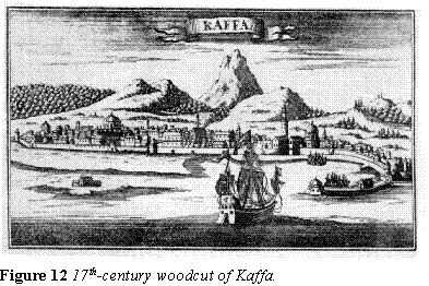
Genoese merchants remained in Crimea until the last quarter of
the 15th century, some 20 years after the fall of Constantinople.
The departure of the last European merchants did not mean the end
of seafaring in the Black Sea, however. Kaffa remained an important
center for the slave trade during the Tatar and later Ottoman occupations
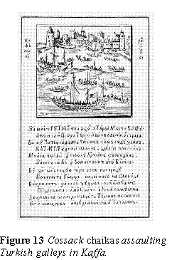
of Crimea (Figure 12). Ukrainian Cossacks
launched several seaborne attacks on Ottoman ports throughout the
Black Sea during the late-16th and 17th centuries.
Their disruption of Black Sea trade was a source of major concern
for the Ottomans. Figure 13 illustrates Cossack
chaikas attacking Turkish vessels in Kaffa harbor.
While Greeks and other Europeans continued to live in Crimea throughout
the period of Ottoman occupation, European traders no longer played
an active role in Black Sea seafaring. The Black Sea became an 'Ottoman
lake' and knowledge of the region among Europeans began to fade.
The highly accurate, detailed Italian maps of the 13th
through 15th centuries ( see cover plate)
reflect a deep familiarity with the Black Sea - the product of intensive
maritime activity. In contrast, maps of the 17th century
are crudely executed and contain numerous inaccuracies. These inaccuracies
remained unchanged until 1700 when Cornelius Cruys, a Dutchman serving
as admiral of the new Russian fleet in the Sea of Azov, corrected
the maps.
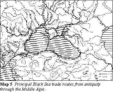
This brief survey of the history of seafaring in the northern Black
Sea illustrates the great potential for underwater archaeology in
the region. Wind and current patterns, as well as a central geographic
position, make Crimea an ideal location to search for shipwrecks.
Maritime trade routes have crossed Crimea since antiquity (Map
5). For more than 2000 years, ships of every design have
sailed along the peninsula; many of these voyages ended disastrously
in shipwreck. These ancient tragedies have left a remarkable, and
largely untapped, archaeological resource.
Research Goals and Methodology
The primary research goal of this project is to evaluate the underwater
archaeological resources of the southern coast of the Crimean peninsula,
specifically in the area between Sevastopol and Fedosia. The scope
of the project is limited to the period between the Bronze Age and
the late Middle Ages. The joint survey phase of the project will
last from July 1 through September 5, 1997. The joint project field
team will be comprised of 7-10 members, including Mr. Gidden, Mr.
Pevny, Ms. Romey, Mr. Zelenko, and several Ukrainian archaeologists
and students. The survey methodology for the initial season will
be limited to diving investigation; the use of remote sensing equipment
in future seasons is being considered. Large sections of the coast
are free of submerged rock formations, making the use of remote
sensing equipment highly suitable. In addition to a general survey
of the coastline, project participants will investigate six specific
sites, both ports and shipwrecks, for further in-depth research.
These sites include the ancient port of Amphineon, mentioned in
"Periplus Ponti Euxini"; areas around Cape Ai-Todor (site of the
ancient Roman fortress of Charas); and Karantinnaya Haven (ancient
Chersonesos). The sites will be evaluated for possible excavation;
the team hopes to begin excavation of the most significant site
during the summer 1998 season.
Through association of archaeological resources with known sites
from historical sources, this project intends to develop a broader
understanding of the maritime cultural landscape of southern Crimea
and the role of the Black Sea and Crimea in the economic and political
development of larger, neighboring systems. In addition to underwater
investigation, project members will attempt to locate and evaluate
museum and archival data pertaining to the maritime history of the
region to supplement material identified during the survey. Following
completion of the initial season of fieldwork, the project members
intend to publish their findings in an appropriate format.
The American team brings a wide range of archaeological skills and
experience to the project. Team members have worked in Israel, Turkey,
and the United States, participating in coastal surveys, shipwreck
and harbor excavations, and ship replica construction. In addition
to field experience, team members have academic preparation in ancient
and medieval history and seafaring, ship reconstruction, and nautical
archaeology. All three members have been trained in artifact recording,
site mapping, ship drafting and conservation. While removal of any
material from Ukraine is neither feasible nor desirable, project
members will assist in all aspects of the necessary conservation
and research of any material recovered during the survey.
Goals of Preservation and Education
The team members share a common dedication to bringing the benefits
of archaeology to the public. This mission includes two elements:
preservation and education. The privilege of archaeological excavation
brings the responsibility of recording and preserving the information
and material that is recovered, insofar as it is feasible. This
is, however, not enough. Excavation is the process of controlled
destruction of archaeological sites. Without publication of results,
archaeology cannot be distinguished from treasure hunting. Publication
of scholarly and popular articles allow both scholars and the general
reader to benefit from archaeology.
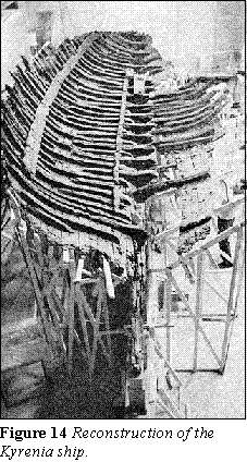 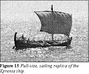
Education need not be limited to publication. INA archaeologists
have worked closely with cultural ministries and museums to bring
the results of their work to an international audience. The excavation
of the Kyrenia shipwreck, mentioned above, led to a museum display
of the ship's reconstructed hull and cargo (Figure 14).
This reconstruction, directed by Texas A&M Professor Emeritus
Richard Steffy, formed the basis for a full-size, sailing replica
of this 4th-century BC vessel (Figure 15).
Similarly, close cooperation with the Turkish Ministry of Culture
has resulted in the development of the Mediterranean's premier museum
for underwater archaeology in Bodrum, Turkey. This museum, toured
by thousands of visitors from around the world, houses artifacts
from several shipwreck excavations as well as a full-size, partial
replica of the 7th-century Byzantine merchant ship excavated
off Yassi Ada, Turkey (Figure 16). Crimea, with
its enormous potential for underwater archaeology, will some day,
we hope, house a similar museum. |